The Overland Telegraph Line - construction strategy for the central section.
- Home, index, site details
- Australia 1901-1988
- New South Wales
- Overview of NSW
- Telegraph lines
- Telegraph Offices
- Date stamps
- Forms
- Envelopes
- Rates
- Stamps
- Queensland
- Overview of Qld
- Telegraph lines
- Telegraph offices
- Date stamps
- Forms
- Envelopes
- Rates
- Stamps
- South Australia
- Overview of SA
- Telegraph lines
- Telegraph Offices
- Date stamps
- Forms
- Envelopes
- Rates
- Stamps
- Tasmania
- Overview of Tasmania
- General developments
- Reports
- Organisation
- Telegraph lines
- Telegraph Offices
- Date stamps
- Railway lines
- Forms
- Envelopes
- Rates
- Stamps
- Overview of Tasmania
- Victoria
- Overview of Vic.
- Telegraph lines
- Telegraph offices
- Date stamps
- Forms
- Envelopes
- Rates
- Stamps
- Ephemera
- Western Australia
- Overview of WA
- Telegraph lines
- Telegraph Offices
- Date stamps
- Forms
- Envelopes
- Rates
- Stamps
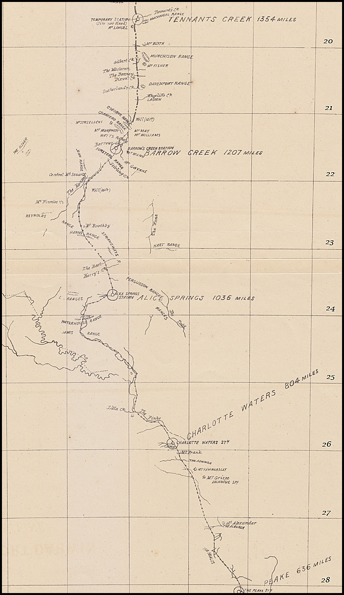
The central section, from latitude 26° 52' to 19° 30' - or 626 miles - was undertaken by five distinct Government parties, each having 100 to 120 miles of line to put up. The central sections were respectively designated A, B, C, D, and E.
The five components were completed before the end of 1871 so that, had the operations in the Northern Territory been equally successful, the line could easily have been opened by the 2nd or 3rd January, 1872. Indeed in January 1872 in the forenoon of Wednesday, 3rd January, communication was established as far as the Alice Springs in the MacDonnell Ranges (Section C) — a distance of between 800 and 900 miles from Port Augusta, or between 1,100 and 1,200 miles from Adelaide. The Alice Springs are about 100 miles south of Central Mount Stuart. The telegram from Mr. Benjamin Clark, who went to supervise the opening of the line, stated that he and the other operators had arrived at the Alice Springs Station on Thursday, the 28th December, 1871.
The description below is based on Todd's 1 January 1873 Report published in the Adelaide Advertiser on 11 January 1873 (p. 11).
Central section -
Each Section had an Overseer as well as a sub-overseer, an assistant and between 16 and 10 men.
Iron and wood poles are planted alternately from the south end of the section to the angle south of the Stevenson, a distance of 30 miles. The wooden poles are stout gum saplings, of about 10 inches at butt and five or six at the top. I (Todd) did not see a single bad pole on the line. Twenty to the mile are planted throughout. The line has been laid out with judgment, crossing the creeks at the best places and at right angles, and carefully avoids low lands subject to inundation.
Constructed under the supervision of Mr. G. R. McMinn, this Section extended from latitude 25° 30' to 24° 0' or 142 miles nine chains. It was commenced in February, 1871 and completed in every respect by the 15th November following when, in accordance with instructions, Mr. McMinn went north to complete Section C, Mr. Mills, the officer in charge of that section and his party going forward to the north end of Section E to assist Mr. Harvey.
The line on Section B follows, within a short distance, the Finke to its junction with the Hugh, a little south of latitude 25°, and keeps a generally northerly direction to the junction of the Alice and Hugh, from whence it follows the Hugh, making a considerable detour to the north-west, passing through the Hugh gorges of the James and Waterhouse Ranges, joining on to Section C at the latter. It crosses the Finke and Hugh several times, but is quite safe.
At the first or Marchant's Crossing of the Finke, immediately north of Section A, the line was carried away in January, 1872, but Mr. McMinn has now planted a mast on either side at some distance from the bank. On the south side the mast is 52 feet long, planted eight feet in the ground, and on the north side, which is higher, 39 feet. Both masts are securely strutted and stayed, and the longer one is built round with several tons of large stones.
For about 60 miles along the Finke the line crosses heavy sandhills, covered for the most part with spinifex and low bushes, relieved in places by clusters of fine black oaks (casuarinas); but the country im proves north of this, and is generally good and well grassed. Water is found in many places in the Finke, Hugh and the smaller creeks running into them—at Marchant's Springs, Mount Musgrave, Polly's Springs (horseshoe bend on the Finke), at St. Patricks Camp, Whinham Springs (near Mount Burrell), first crossing of Hugh, Kragen's Creek, junction of Minnie Creek and Hugh, Stuart's Camp (in the James Range), McClure's Springs and Owen's Springs.
The poles throughout this section are sound good gum saplings, rather over than under the specified size. I did not see a bad pole on the line, which was substantially constructed throughout.
There are white ants on the sandhills and on the flats near the Finke but they have made very little impression on the poles as yet. Some poles which had been in the ground for nineteen months were recently taken out by Mr. McMinn, who found that the white ants had commenced at the foot of the pole where they had eaten out a hole about the size of his finger.
I quite concur in Mr. McMinn's recommendation that iron poles should be planted when necessary to repole, alternately with wood on the sandhills, but on the other portion of the section no white ants have been seen and, as timber is plentiful in the Finke and Hugh, there may be no occasion to use iron poles.
Constructed under the supervision of Mr. W. W. Mills, this Section extended from latitude 24° to 22½° - or 131 miles - was commenced 22 March, and finished 29 December, 1871.
The section starts from Lawrence's Gorge on the north side of the Waterhouse Range, from whence the line crosses a well grassed mulga plain, following up the Hugh and then the Jay, both of which are splendidly timbered, to the foot of the MacDonnell Ranges where it crosses a low gap and turns abruptly to the eastward, keeping between rugged parallel ridges for several miles to Fenn's Gap, where a practicable crossing was found and the track finally emerged from the range about 12 miles north.
It took a long time to find that pass through the Macdonnell Ranges (about latitude 24°) which would allow wagons through. Until that passage was determined, no work could occur in the three Sections to the north. It was not until March 1871 that Mills was able to find a gorge (now Heavitree Gap) which opened onto a grassed plateau basin with a pool of clear water. Mills called this place Alice Springs after the wife of Charles Todd.
Leaving the MacDonnell Ranges, the line crosses the mulga plains to the Reynolds Ranges, keeping to the west of the Strangways Range, and crossing a low gap in the intervening Hann's Range. The plains are well-grassed but the mulga is very dense in places and water is scarce but can be obtained by sinking on the flat. A native well was opened one mile to the west of the line near the Burt, 25 miles from the MacDonnell Ranges, which yields a permanent supply at a depth of only ten feet. The next water is found 35 miles further on at a native well in the gap at Hann's Range. A well 50 feet deep was sunk in the Burt but yielded only a small supply. Mr. Mills discovered a running brook in the Strangways Ranges, nine miles N.E. of the line, which he believes to be permanent, as it was still running when he last saw it in July, 1871 in the middle of the dry season.
Owing to the scarcity of surface water between the MacDonnell and Reynolds Ranges for a distance of 70 miles, and the absence of suitable timber, the construction of this portion of the line was attended with considerable difficulties. With few exceptions, however, the line is equal to what we have in the settled districts. From the Waterhouse to the north side of the MacDonnell Ranges, the poles are all good full-sized gum poles. Between the MacDonnell and Reynolds Ranges, they are not so good but are quite sound and in the mulga there are more white ants, the soil being a light red sandy loam, splendidly grassed.
Constructed under the supervision of Mr. A. T. Woods (who. was also the Superintendent of the five Central Sections), this Section extended from lat. 22° 30' to 21° - or 124½ miles.
This section followed, for a considerable distance, the Woodforde, Hanson, Stirling and Taylor Creeks from which the poles have been got. The supply was not very abundant and difficulty would, I fear, be experienced in getting more near the line. About 500 poles, for 25 miles, were obtained from the Woodforde, which was stripped of all its serviceable trees for a distance of 15 miles. The line follows the Woodforde for about 30 miles, where the creek ceases to have any defined channel, though it no doubt in high floods runs into the Hanson, which the line follows for nearly 20 miles. Leaving the Hanson, the line crosses the Taylor 10 miles on, and then passes over the Forster Range between Mounts Mann and Gwynne to Barrow's Creek, where we have a station, and again crosses the main channel of the Taylor, 22 miles beyond Barrow Creek Station.
The line throughout this section has been erected in a most creditable manner. The poles are straight, of the full size, and are a very hard description of gum timber, which should, I think, last a number of years. The flats into which some of the creeks run will yield a limited supply of gum saplings for repairs, and there is probably a reserve left in the Hanson below the line; but no donbt eventually we shall have to place iron poles on this and the adjoining section.
The country is generally well grassed and admirably adapted for stock. Mr. Woods, in his report remarks:
"Adjacent to this part of the line is some very good stock country, not only open and attractive in appearance, but probably the most healthy country for stock north of the MacDonnell Ranges—perhaps on account of the prevalence of saltbush, which is deficient or altogether absent elsewhere. There is muoh good grazing country throughout the length of Section D. The grasses are not rank; they are varied and nutritious, our stock thriving welL By judicious burning, green grass can be secured throughout the year, many of the grasses being perennial".
There is a large admixture of spinifex, but after burning, other grasses spring up with it.
With regard to water, in ordinary seasons there is probably an ample supply all the year round and can generally be got by sinking in the sand in the creeks which have an uneven clay bottom covered with sand. Mr. Woods states that the clay is very tenacious and that, wherever from inequalities in the bed of the creek a hollow basin is formed, water can be obtained by sinking in the sand. There is at present a large supply at Barrow Creek, where the spring has been running since it was first opened out; but, as a precautionary measure, I would advise two or three wells to be sunk in the most likely places, by which means I have not the slightest doubt that a permanent supply could be obtained in the driest seasons.
The white ants are not very numerous on this Section and, up to the present time, have done little or no damage.
Constructed under the supervision of Mr. W. Harvey, this Section extended from latitude 21° 30' to 19° 30', or 107 miles 76 chains. Mr. Harvey also erected 82 miles 16 chains 41 links of the line north of Section E, to latitude 18° 26½' - or in all over 190 miles of line - having the assistance of Mr. Mills for a few months.
Leaving Adelaide in August, 1870, Harvey and his team did not reach their destination to start work until the 24th May, 1871 - the first poles being planted on the 1st June. The wire was stretched to the end of the section by the 1st November 1871 - the last 34 miles having at first only ten poles to the mile, according to Todd's instructions dispatched by special mail in July when he began to have a reason to fear delay on the northern side. Mr. Harvey then pushed on north of Section E and extended the line another 82 miles. The intermediate poles, making 20 to the mile throughout, were planted before he left the work.
The country in this section, and more so to the north of it, was rather poor, the soil being mostly an intermixture of sand and clay, covered with spinifex and low scrub, except immediately along the creeks, where the soil was richer and the flats were well grassed. Here and there were belts of mulga, where grass was generally plentiful. The ranges, which were mostly quartzose sandstone resting on granite, nowhere rising over 600 feet, seldom so high, were covered with spinifex. In some places, vast boulders of granite were scattered on the surface, lying singly or piled up in curious fashion to a considerable height. Quartz reefs were frequently met with and a soft micaceous clay slate, nearly vertical, ran north and south.
Mount Samuel—a quartzose sandstone hill, some 250 or 300 feet high, a little to the west of the line—was crowned with immense ironstone rocks, highly magnetic, every fragment being polarized—rendering the compass-needle of the theodolite useless.
Timber of any size was wholly confined to the creeks; and there the description suitable for telegraph poles was by no means plentiful. Mr. Harvey had considerable difficulty in procuring the quantity required, having to cart poles long distances. Many of the poles on the northern end of Section E, and from there to the end of Mr. Harvey's work, were small and very crooked; they were, however, the best he could procure. The bulk of the poles were full sized and good; the others, although unsightly and small, were sufficiently substantial and were ex[ected to last as long as the rest. When this section was repoled, Todd advised iron through out; indeed, iron poles for the north end of the section had already been provided.
North of the Gilbert the white ants became more numerous and a beetle, termed the borer, also became numerous and destructive to the poles and insulator pins.
The best-watered creeks on Mr. Harvey's section are the Bonney, Tennant's Creek and Attack Creek, the first and last being probably permanent. A well has been sunk at the station on Tennant's Creek. Water is found in most of the other creeks, lasting for some months, and two or three wells were sunk which require timbering.